
Dubai’s Metro system continues to grow and improve every year. The latest Dubai Metro Map 2026 brings exciting updates that make it easier than ever to travel around the city. Whether you’re a tourist or a daily commuter, knowing the current routes and key stations will help you move with confidence.
In this guide, we’ll walk you through what’s new on the map, the major lines and stations, and how to read and use the Metro map effectively. We’ll also highlight major landmarks and attractions you can reach via the Dubai Metro Map in 2026.
What’s New in the Dubai Metro Map 2026?
The 2026 update to the Dubai Metro Map reflects the city’s rapid development. Several new stations have been added, and existing routes have been extended to improve convenience for daily riders and visitors. These changes aim to reduce traffic, improve access, and connect more areas of Dubai.
You’ll also see better integration between Metro lines, buses, and other transport services. The map is designed to be user-friendly, with clearer color coding and zone divisions. Here’s what’s been updated this year.
Updated Routes and Station Additions
Several new stations have been added to both the Red and Green Lines in 2026. These include stops in growing residential areas and upcoming business hubs. The new routes improve travel times and reduce the need for long transfers.
Expansion of the Red and Green Lines
The Red Line now stretches further into Dubai South, while the Green Line has been extended to serve more communities near the Dubai Creek. This expansion means more direct access to schools, malls, and medical centers. In addition to Red and Green Line enhancements, Dubai is actively building the new Blue Line, a 30 km extension featuring 14 stations, including what will be the world’s tallest metro station at 74 meters in Dubai Creek Harbor.
Integration with Future Metro Plans
The 2026 Metro Map also includes plans for future lines and feeder routes. These align with the Dubai 2040 Urban Master Plan and aim to connect the Metro with tram lines, buses, and even autonomous transport in the future.
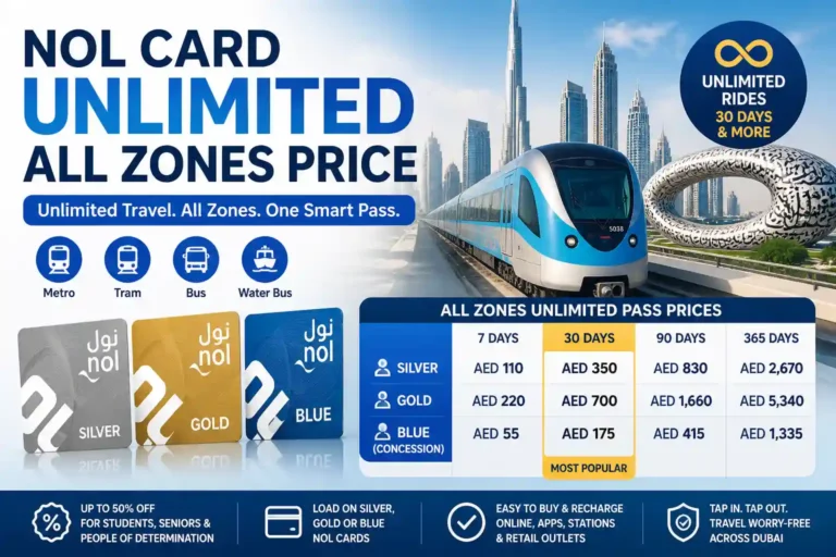
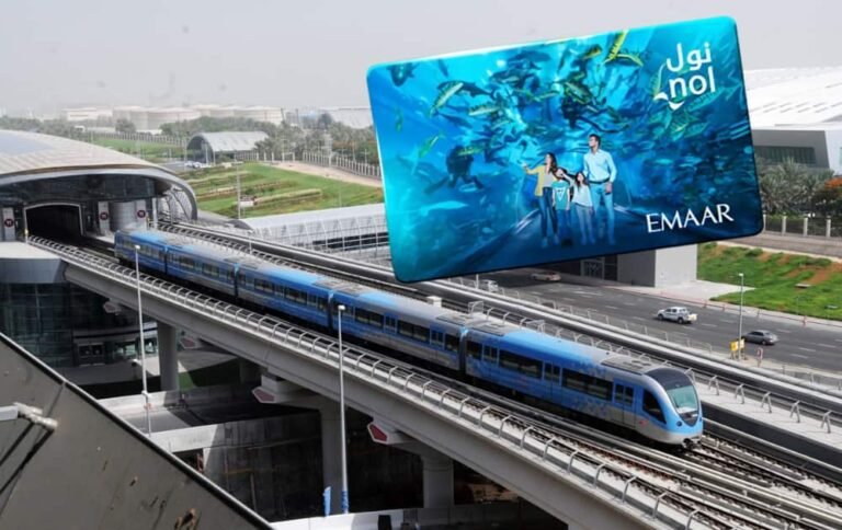
If you regularly travel through different metro zones in Dubai, it’s always smart to Check NOL Card Balance to ensure uninterrupted travel.
Overview of the Dubai Metro System
Operated by the Roads and Transport Authority, the Dubai Metro is one of the world’s most advanced fully automated, driverless rail networks, playing a vital role in the city’s public transportation system. It currently operates two main lines—the Red Line, which runs along Dubai’s central corridor from Centrepoint to Expo City, and the Green Line, which connects key cultural and commercial districts across older parts of the city.
A new Blue Line is also under development, aimed at expanding connectivity to emerging residential and business hubs. Spanning over 80 kilometers with strategically placed stations near major malls, offices, and tourist attractions, the Dubai Metro continues to be a fast, reliable, and essential mode of daily travel for both residents and visitors.
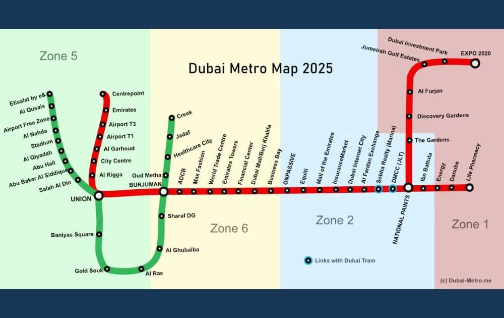
Detailed Breakdown of Dubai Metro Lines and Key Stations in 2026
The Dubai Metro covers most of the city with two main lines, Red and Green. Each line includes major stations that serve business, tourist, and residential areas. Knowing these key stops helps plan your trips more efficiently.
This section outlines the main stations, line routes, and where the two lines connect. Whether you need to get to the airport, the mall, or an office tower, this breakdown is your go-to guide.
According to Dubai’s 2040 Urban Master Plan, the Metro system is set to expand from 64 to 140 stations by 2040 — nearly doubling in size to meet the growing demand of residents and visitors (The National News).
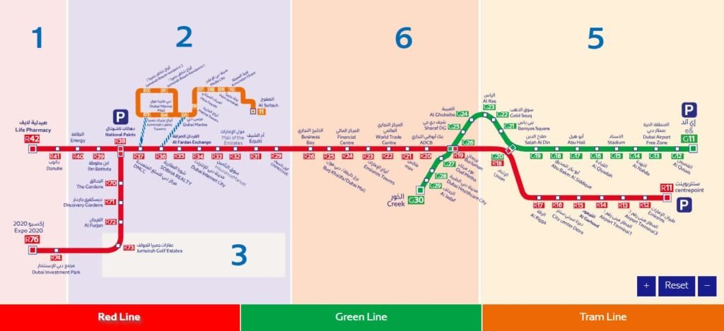
Red Line – Key Stops and Destinations
The Red Line runs from Centrepoint to Expo 2020 and now extends toward Al Maktoum International Airport. Major stops include BurJuman, Dubai Mall/Burj Khalifa, and Business Bay. It’s perfect for reaching shopping centers, tourist attractions, and business districts.
Green Line – Important Stations and Transfers
The Green Line covers areas like Al Qusais, Deira, and Dubai Healthcare City. It’s ideal for residents and students heading to universities, schools, and clinics. Stations like Al Fahidi and Union offer easy access to cultural and heritage zones.
Interchange Stations Connecting Red & Green Lines
Stations like Union and BurJuman are interchange points where passengers can switch between the Red and Green Lines. These are clearly marked on the Dubai Metro Map and help simplify multi-line travel across the city.
First days in Dubai? The Virtual Nol Card ensures smooth public transport access. Find out how to recharge online and track your balance effortlessly.
Major Landmarks Accessible via Metro in 2026
The Dubai Metro connects some of the city’s biggest landmarks. Whether you’re shopping, sightseeing, or commuting to work, the Metro can take you there quickly and affordably.
The highlights of major destinations accessible through both the Red and Green Lines are given below. Additionally,, new areas are being added in 2026.
Tourist Attractions on the Red Line
Popular tourist spots like the Burj Khalifa, The Dubai Mall, Mall of the Emirates, and Dubai Marina are all located along the Red Line. Expo City and future parks near Dubai South are also accessible via extended routes.
Business and Residential Areas on the Green Line
The Green Line connects neighborhoods like Al Qiyadah, Al Nahda, and Oud Metha. These areas are home to schools, clinics, and residential towers. Many professionals and students prefer this route for daily travel.
Upcoming Areas with New Metro Access
New developments like Dubai Creek Harbour and parts of Dubai Silicon Oasis are getting Metro access through future lines. These additions aim to improve access for fast-growing communities.
Whether you’re a resident or tourist, checking the Dubai Metro timings today ensures you travel smoothly and reach your destination on time. This updated 2026 schedule helps you plan your trips more efficiently.
Conclusion
The Dubai Metro Map 2026 makes navigating the city easier than ever. With new stations, extended lines, and smart integrations, it offers faster, smoother, and more convenient travel. Whether you’re a tourist or a resident, understanding the Metro map helps you save time and money on every journey.
Visit: How to Recharge Your NOL Card Online in 2026